Introduction
 The Santa Ana River Mainstem Project is designed to provide flood protection to the growing urban communities in Orange, Riverside and San Bernardino Counties . The proposed improvements to the system cover 75 miles, from the headwater of Santa Ana River east of the city of San Bernardino to the mouth of the river at the Pacific Ocean between the cities of Newport Beach and Huntington Beach.
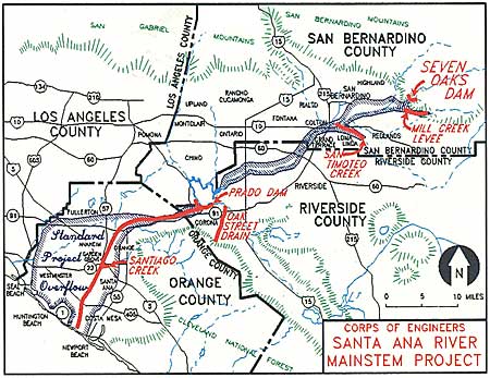
The project will increase levels of flood protection to more than 3.35 million people within the three county areas. The project includes seven independent features: Seven Oaks Dam, Mill Creek Levee, San Timoteo Creek, Oak Street Drain, Prado Dam, Santiago Creek and Lower Santa Ana River .
The rapid growth and development of Southern California has decreased effectiveness of the present flood control system. Areas that would absorb rainfall runoff have been reduced as well as the water holding capacities of reservoirs. Today, the most severe flood likely to occur along the river would cover more than 110,000 acres to a depth of three feet and would amount to more than $40 billion in economic losses.
The Santa Ana River Mainstem project is designed to provide flood protection for residences and business in the Southern California communities of Orange , Riverside , and San Bernardino counties. All three counties, collectively, are working closely with the U.S. Army Corps of Engineers to design and construct the project.
Project Description
The Santa Ana River Mainstem Project is located along a 75-mile reach of the Santa Ana River in Orange, Riverside and San Bernardino counties. The plan for flood control improvements includes three principal features:
- Lower river channel modification for flood control along the 30 miles of the Santa Ana River from Prado Dam to the Pacific Ocean.
- Construction of Seven Oaks Dam (about 38 miles upstream of the existing Prado Dam) with a gross reservoir storage of 145,600 acre-feet.
- Enlargement of Prado Dam to increase reservoir storage capacity from 217,000 acre-feet to 362,000 acre-feet.
Environmental & Recreation
The project includes environmental features such as enhancement of a degraded marsh area at the mouth of the river, thereby providing significant value as wetland habitat for migrating waterfowl and the California least tern, a federally listed endangered species.
The plan provides for the acquisition of Wildlife and biological mitigation lands, restoring temporary loss of habitat values, cultural mitigation, and a 32 mile system of recreation trails including:
In the Santa Ana Canyon, 1,100 acres of floodplain has been preserved as open space. A resource, habitat and floodplain management plan has been developed to preserve open space and wildlife habitat in the area.
A marsh restoration program consisting of ninety-two acres of degraded wetlands at the mouth of the Santa Ana River has been purchased and restored through re-contouring and the planting of wetland plant species. This wetland is providing significant wetland habitat for migratory waterfowl and the California Least Tern, and other endangered species.

SARP History
The Orange County Flood Control District (OCFCD) was formed by the State Legislature in 1927.
The Federal Flood Control Act of 1936 authorized a flood control project to protect metropolitan Orange County that included the construction of Prado Dam. Major floods in Orange County in 1937 and 1938 prompted Congress to direct the U.S. Army Corps of Engineers (Corps) to proceed with design and construction of the dam, which was subsequently completed in 1941.
In 1962, the OCFCD asked the Corps to review the federal flood control work authorized by the 1936 Federal Flood Control Act. The restudy was approved in 1964, and was completed in 1975 by the Corps LA District Office. During that period of study, it was concluded that the existing Prado Dam and Santa Ana River improvements only provided a 70-year level of flood protection. The report recommended an “All River Plan” alternative (later renamed the Santa Ana River Mainstem) that included:
-
a large flood storage reservoir in San Bernardino County (that became Seven Oaks Dam),
-
the raising of Prado Dam (to increase flood storage capacity) and improvement of its outlet works, and
-
reconstruction of the lower Santa Ana River Channel to increase its capacity.
The goal of the 1975 study was to develop a plan to address the “Standard Project Flood”, one that has about a ½ percent chance of occurring any given year, or that statistically tends to occur about once every 200 years.
The Corps was authorized by Congress in the Water Resources Development Act of 1976 to undertake the Phase 1 General Design Memorandum (GDM) for the project, which was completed in 1980. In 1986, the Phase 2 GDM (a more detailed study) was completed and submitted to Congress, requesting authorization for a “new construction start”. The project was authorized for construction in 1988, and the three Local Sponsors (Flood Districts of Orange, Riverside and San Bernardino Counties) signed a Local Cooperation Agreement (LCA) with the Corps in 1989. The LCA defined the roles and responsibilities for the project among the four parties. Construction began in 1989 with improvements to the Lower River near the Pacific Ocean.
Over the ensuing 28 years, much of the construction work has been completed but a number of key elements remain.
As of 2017, Seven Oaks Dam has been completed and turned over to the Local Sponsors for operation and maintenance. Approximately 95% of the reconstruction work in the lower river channel has been completed with remaining work consisting of bank protection improvements in the Yorba Linda area (under construction), and strengthening of the bridge piers supporting the BNSF Railroad in Corona. The Prado Dam embankment has been raised and the outlet works have been reconstructed to convey discharges of up to 30,000cfs. Additional lands for the expansion of the Prado reservoir still need to be acquired, several protective dikes in the Prado basin remain to be built and the spillway for Prado Dam has yet to be raised. It is anticipated that the project may be completed in 2021, pending Federal appropriations.