
Content block block-1599025727-1775881870
The San Juan Creek Flood Risk Management Feasibility Study is a joint study between the United States Army Corps of Engineers and the Orange County Flood Control District. The purpose of this feasibility study is to evaluate flood risk management alternative measures along the lower portions of San Juan, Trabuco, and Oso Creeks. The San Juan Creek Watershed encompasses approximately 176 square miles of southern Orange County and western Riverside County in southern California. The study is a spinoff of the earlier San Juan Creek Watershed Management study, with a focus on flood control in the lower portions of the watershed.
The study area extends along approximately 10.5 miles of San Juan Creek from the Pacific Ocean to the southern end of Ronald W. Casper’s Wilderness Park, along 9.5 miles of Trabuco Creek from its confluence with San Juan Creek to its confluence with Tijeras Creek and along 4.5 miles of Oso Creek from its confluence with Trabuco Creek to just north of Oso Parkway.
The planning objectives for the study are:
- To reduce the risk of flood damages in lower portions of the watershed along San Juan, Oso and Trabuco Creeks
- To address stream bank erosion and channel instability in the lower portions of San Juan, Trabuco and Oso Creeks.
- To maintain habitat function and values in the study area to the extent practicable
After failing to receive Federal Appropriations for a number of years, the San Juan Creek Feasibility Study was ultimately discontinued by the Army Corps of Engineers.
Accordion section
The report will be a combined feasibility report and environmental impact statement complying with requirements of the U.S. Army Corps of Engineers and the Council of Environmental Quality, and is intended to reduce duplication and paperwork. The integrated report will be prepared to:
- Summarize the findings, results, and data collected for historic and existing conditions in the study area, and to forecast the most likely future without-project conditions, pertaining to physical and biological resources, cultural resources, socioeconomics, and recreation
- Identify problems, opportunities, objectives, and constraints for the study area
- and formulate preliminary alternative plans
Without-Project Conditions
The lower portions of San Juan, Oso and Trabuco Creeks are currently adversely impacted from a variety of water resource and related land resource problems. Most of the issues stem from widespread changes in the watershed, from the initial conversion of natural habitat for agriculture, followed by urbanization. The results can be seen in the changed hydrologic regime, channel instability, habitat loss, ecosystem degradation, and decline in water quality. Development in the watershed has replaced natural habitat with structures, roads, and other infrastructure; natural channels have been replaced by drains, culverts, and engineered channels; paved surfaces allow less infiltration and create greater runoff within remaining natural channels; Large rainfall events produce larger runoff volumes, delivered with higher velocities, resulting in higher rates of erosion and increased channel instability. These changes have produced widespread negative trends in the immediate area of San Juan, Oso, and Trabuco Creek channels. The trends include channel degradation (incision of the invert or channel bed); decline in floodplain moisture (lowering of the water table) resulting to loss of riparian habitat and associated wildlife; expansion of the extent of invasive species; and damage to nearby infrastructure (utilities, roads, trails). Lower San Juan and Trabuco Creeks contain the most unstable reaches in the watershed drainage system.
Preliminary Measures and Alternatives
The integrated report will present preliminary alternative measures that address the problems and opportunities identified through the planning process. Measures will be organized by broad categories such as: flood risk management, channel stabilization, habitat improvement/preservation, and water quality improvement. Measures carried forward will be combined, in various configurations, to form a preliminary set of alternative plans. These preliminary plans will be developed to encompass the broadest range of potential alternatives and will be subjected to a more rigorous evaluation. Preliminary plans include flood risk management features to protect adjacent infrastructure and property; stabilization and protection of existing channel and floodplain; and reconnection of upstream with downstream aquatic habitat. A No Action plan was also assessed.
Feasibility Study Documentation Process
Future documents that will be released during the course of the feasibility study will include:
- A report summarizing alternatives formulation, evaluation, and identification of a tentatively recommended plan
- Draft feasibility report for public review
- Pre-final feasibility report
- Final feasibility report. Environmental compliance documentation will be integrated into the general investigation feasibility study
OCPW has taken measures to address the most critical risk areas of San Juan and Trabuco Creeks to protect the surrounding community from the risk of levee failure through sheet pile improvements. The eight phased sheet pile improvements are located along 8,200 linear feet of San Juan Creek between Stonehill Drive and the I-5 freeway, as well as 8,400 linear feet of Trabuco Creek from its confluence with San Juan Creek to upstream of Del Obispo Street. The sheet pile will be installed through 14 to 17 feet of levee and extend 31 to 34 feet below the channel bottom for a total depth of approximately 48 feet from the top of the levee, providing immediate and long-term bank stability in the segments. Phases I through III for have been completed.
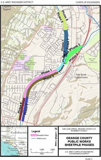 Eight Sheetpile Phases
History
The creeks (San Juan, Oso, and Trabuco) were channelized by Orange County without Corps involvement during the 1960’s with slope protection consisting of 4-inch thick unreinforced concrete panels. Storm flows have scoured the sandy channel invert below the bottom of the embedded unreinforced concrete channel lining leading to uplift and loss of the concrete panels during storm events in 1998, 2005 and December 2010. During the 1997-98 storms a pedestrian bridge on Trabuco Creek upstream of Del Obispo Street Bridge was severely damaged by flooding to the point that it needed to be rebuilt. In addition, the embankment adjacent to the San Juan Capistrano City Hall was breached due to loss of the concrete channel lining and significant erosion of the embankment fill. The Corps provided emergency reconstruction and rehabilitation of the channel levees under PL 84-99 following the significant damage and near failure. During the 2005 storms, approximately 1,250 feet of channel lining was lost on San Juan Creek and the exposed earthen levee was nearly lost due to scour. Emergency placement of large rip rap was required to contain storm flows. During the emergency, five surrounding neighborhoods were evacuated. OCPW again received PL 84-99 assistance in the flood fight and immediately after the storms portions of the damaged levee were patched with grouted stone. Since the 2005 storm event, the unstable levees have continued to deteriorate, most recently in December 2010, when a storm event caused significant damage and near failure of levees protecting surrounding residential areas.
Stakeholders/Study Participants
This effort is being conducted and coordinated by the U.S. Army Corps of Engineers, Los Angeles District and Orange County Public Works (OCPW). In addition, Federal, state and local government agencies; environmental resource agencies; interest groups; and other stakeholders provide valuable contributions to the evaluation process.
Hydrology Analysis was completed for San Juan Creek Watershed which includes San Juan, Trabuco, and Oso Creeks. The discharges at these three creeks were determined.
Hydraulic Analysis was completed on San Juan, Trabuco, and Oso Creeks. The water surface elevations for different discharges were calculated.
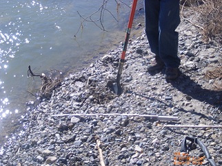
Sedimentation Analysis was completed on Trabuco and Oso Creeks to determine the erosion and deposition of the creeks. Soil samples were collected at Trabuco and Oso Creeks. The San Juan Creek Analysis was completed by Orange County.
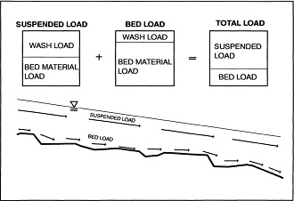 Sediment Sampling Types of Sediment Load
 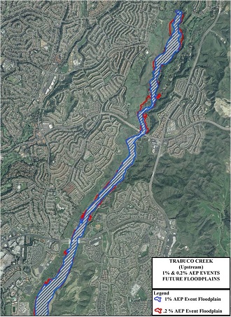 Future Floodplains
The project study limits have been analyzed for background existing geotechnical concerns including: earthquakes, Tsunamis, liquefaction, landslides and seiches.
The background existing conditions for geology, soils, ground water and previous geotechnical investigations of flood protective structures have also been reviewed and described.
Future geotechnical work will involve further review and description of existing geotechnical background information and studies. This work will also continue with geotechnical engineering analysis of foundation conditions for future suggested project alternatives. Specific support work and analysis may consist of field collection and geotechnical lab testing of soil and sediment samples; settlement, liquefaction and slope stability. Geotechnical recommendations will be given for excavation dewatering, foundation preparation, flood protection remedies, foundation and flood protection materials and their sources.
 Example project study Site Geology, no scale.
 Example project study Liquefaction Map, no scale.
 Example project study Landslide Map, no scale
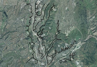
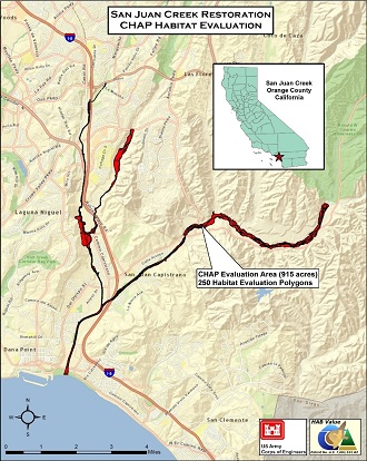
Northwest Habitat Institute (NHI) has employed the Combined Habitat Assessment Protocols (CHAP) habitat evaluation method on the San Juan Creek project area (which includes sections of San Juan Creek, Trabuco Creek, and Oso Creek) to determine baseline habitat value for the site. The project area was analyzed using Geographic Information System (GIS) software and high resolution aerial photography of the area to divide the project into habitat evaluation polygons based on differences in wildlife habitat type and/or differences in structural conditions. A field visit followed where polygon boundaries were further refined and validated. Field data accounting for each polygon includes: dominant plant species and amounts of invasive species for the tree, shrub and herbaceous layers; structural conditions; and key environmental correlates (KECs). A potential species list of all fish and wildlife for the project area has been developed from the California Wildlife Habitat Relationships database and then refined by the habitat evaluation team along with local observations and literature. The next step will be to relate the field data and species list to the Interactive Biodiversity Information System (IBIS) to obtain functional habitat values measured in Habitat Units (HUs) for each polygon. CHAP is spatially based, and a series of maps are then produced summarizing the results using GIS. Values have been run and a small report for a project sponsor has been completed for a section of Trabuco Creek within the project area.
 San Juan Creek Location
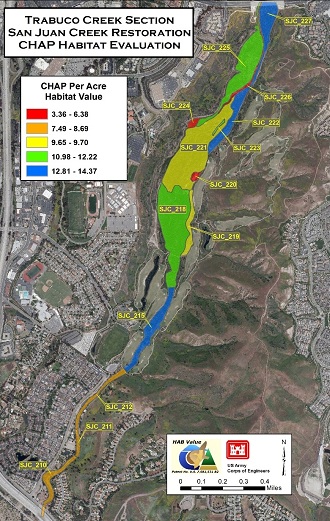 CHAP Habitat Evaluation
For questions and additional information, please contact:
Damien A. Lariviere, USACE Project Manager
(213) 452-4015
damien.a.lariviere@usace.army.mil
Jonathan Guerrero, USACE Study Manager
(213) 452-3795
jonathan.e.guerrero@usace.army.mil
Giatho N. Tran, OC Public Works Project Manager
(714) 647-3972
giatho.tran@ocpw.ocgov.com