
Content block block-1966083089-1776536227
ANNOUNCEMENTS
Press Release
October 26, 2018: US Army Corps of Engineers to Host Public Meetings about the Westminster Flood Risk Management Study
PUBLIC MEETING PRESENTATION
Study overview presented at public scoping meetings. Click here to view
PUBLIC MEETINGS
Wed, Nov 7, 2018
6:30 pm – 8:30 pm
Westminster Civic Center, East-West Events Room, Community Services Building
8200 Westminster Blvd., Westminster, CA 92683
Thur, Nov 8, 2018
6:30 pm – 8:30 pm
Meadowlark Golf Club
16782 Graham St., Huntington Beach, CA 92649
FEASIBILITY STUDY DOCUMENT
The Westminster Watershed Feasibility Study document can be found here
STUDY OVERVIEW
The Westminster Watershed Feasibility Study is a joint cooperative effort between United States Army Corps of Engineers (Corps), and the County of Orange on behalf of the Orange County Flood Control District (OCFCD).
In 2001, the U.S. Army Corps of Engineers initiated a comprehensive watershed study. A Reconnaissance Study was completed in June 2001. Although it was titled the "Westminster Watershed Reconnaissance Study", it covered three Orange County watersheds: Coyote Creek, Carbon Creek, and Westminster.
Upon completion of the Reconnaissance Study, the scope of the study shifted focus away from a watershed feasibility study to a flood risk management feasibility study. Specifically, the study focuses on the Westminster, East Garden Grove-Wintersburg and Ocean View channel systems within the Westminster Watershed. In 2003, the Corps and OCFCD entered into a 50%-50% cost share agreement to develop solutions for comprehensive flood protection, ecosystem restoration and water quality improvements for the watershed.
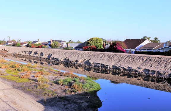
The Westminster watershed is approximately 74 square miles in area and includes urbanized areas in the western corner of Orange County. The watershed lies on a flat coastal plain, and is almost entirely urbanized with residential and commercial development. There are two main channel systems that collect the runoff from portions of the cities of Anaheim, Stanton, Cypress, Garden Grove, Westminster, Fountain Valley, Los Alamitos, Seal Beach and Huntington Beach.
East Garden Grove-Wintersburg Channel, with its principal tributary, the Ocean View Channel, drain into Outer Bolsa Bay and the Bolsa Chica Channel, with its tributaries, the Anaheim-Barber City Channel and Westminster Channel, drain into Huntington Harbour. The sole ocean outlet for both Outer Bolsa Bay and Huntington Harbor is to the north at Anaheim Bay. Because of local flood risks, over 20,000 property owners must participate in the National Flood Insurance Program. In addition, thousands of additional property owners and valuable coastal habitat are also in jeopardy from flooding impacts.
The overall study effort is managed under the direction of the County of Orange, the Corps project manager and study manager. These managers are responsible for all facilitation and coordination, and ensure communication between team members and contractors. The Project Delivery Team includes staff from multiple Corps departments within the Los Angeles District, South Pacific Division and Headquarters, County of Orange staff, and select outside contractors.